


In my first article about the Geology of Minnekhada and area I mused about the long term geological history of Minnekhada. I had my own ideas, but felt that I needed some input from someone who is actually qualified to make an assessment. In the past I have attended presentations from Dr. John Clague. John is the Editor-in-Chief of “Natural Hazards” and is Emeritus Professor at the Department of Earth Sciences at Simon Fraser University. He is also a genuinely great person who is passionate and generous when sharing his detailed knowledge with the community at large. John’s specialty is Quaternary Geology, which basically means a focus on more recent geological events from the last 2.5 million years or so. For us, a lot of that points to cycles of glaciation with a little bit of volcanism and tectonic activity thrown in for good measure.
On a somewhat drizzly day at the end of February, I was honoured to have John and his wife join me for a little tour and a chat at Minnekhada. My questions were numerous but a lot of them focussed around one main theme – What was the source of the interesting knolls and mounds at Minnekhada and the surrounding area? Were the maps put out by the Geological Survey of Canada accurate in saying this terrain was mostly glacially deposited till?
We looked at the High Knoll, we looked at the smaller knolls in the ears of the lodge, and at Minnekhada Farm. We looked at the big picture from a distance. John noted some clear glacial scarring, or striations, typically caused as ice moved over rocks.
OK, so glaciers moved over Minnekhada, no big surprise there, right? In fact the last of many ice ages retreated from our area just around 12,000 years ago. But was there a bigger pattern that could emerge? John would need to take a closer look, from the sky, one that could strip away the trees and look at what lies beneath. For that he turned to LIDAR.
To quote NOAA,
“Light Detection and Ranging, is a remote sensing method that uses light in the form of a pulsed laser to measure ranges (variable distances) to the Earth. These light pulses—combined with other data recorded by the airborne system — generate precise, three-dimensional information about the shape of the Earth and its surface characteristics.”
It is a truly revolutionary technology that has forever changed Earth Sciences, and it was about to help us reveal some more very interesting facts about Minnekhada and see it in a detailed way we would just not be able to do from scrambling around the forest.
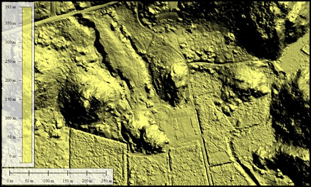
John was able to locate some very detailed imagery taken over Minnekhada. The shaded relief images reveal a side of Minnekhada we could not see without this technology. The first image (below) is overlooking the marsh area, Quarry Road bisects the top left. Of note is the clear NE to SW trend of the sculpted bedrock. Also, the relative flatness of the low lying areas.

This second image (below) mostly overlooks the farm. The horse stables are evident near the center of the image. Several smaller mound structures, as well as gullied glacial sediments can be seen here, and the same NE to SW trend is evident.
So the evidence of glaciation is undisputed. Yes, we have glacial erosion (and more recent stream erosion). Yes, we have deposits. The dominant direction of the erosion can be logically explained by the path taken by a tongue of the most recent glaciers (The Vashon) down the Pitt River Valley. Next time you cross the Pitt River Bridge on foot or bicycle, take a look North and admire that beautiful classic U-shaped valley.
Imagine those glaciers slowly making their way back up towards higher peaks to the North, calving icebergs as they retreat.
The fact that there is clear evidence of glaciers overtopping the mounds, means they were already there when the glaciers came through. But where did they come from. For that we need to go back further in time. Stay tuned for Part Three to learn more about ….
As a footnote I would like to really thank John Clague and his wife for taking time out of their day to visit Minnekhada. It was a real pleasure to learn from one of the best.
To read more about John Clague and his work, please visit the SFU website.
Steve is the Secretary and Vice Chair of the Minnekhada Park Association and a very
active volunteer, who proudly wears the “science nerd” badge.