


In this four part series, our very own Board member, Steve Smith dives deep into the geology in and around Minnekhada Park!
In part two of this Minnekhada Geology series I talked about the use of LIDAR technology, and relied on the consultation of an expert in the field, to spot characteristics in the rock formations at Minnekhada. There is clear evidence of glaciation, likely multiple times. This led to the conclusion that the rocky mounds (like High Knoll) were in place well before the glaciers advanced over most of Western Canada and points south. But how much longer?
OK, but before I go much deeper, a small disclaimer. I am not a Geologist, just a very curious person who believes in lifelong learning. What follows is a hopefully mostly accurate picture in layperson’s language, because, well, I am a layperson.
Back to the question, “how much longer?” We first need to understand where we are situated. Directly north of Minnekhada lies Burke Mountain, part of the Coast Mountain Range. To the east and west are similar peaks, and to the southeast on a clear day you can look in awe at the majestic Mount Baker, just across the border in Washington state, a classic stratovolcano. You might be tempted to think they are part of the same system.They most definitely are not.
While they both have volcanic origins, one set of mountains is much, much older than the other and you could even say they came from different places. “Wait, what…”
Burke Mountain, Eagle Mountain, the North Shore and the Golden Ears form part of the southernmost extent of the Coast Plutonic Complex (CPC), which extends along the entire coast of BC and up into Yukon and Alaska. The CPC is massive collection of igneous, granitic rocks consisting of plutons, each one representing what was once the inner core of a volcano, the magma chamber. The magma cooled and crystallized underground over millions of years, eventually forming the “salt and pepper” granites we are so familiar with in this area.
Through processes of uplift and erosion these plutons were pushed upwards, exposed, and eroded forming the peaks that now surround us. The rocks at Minnekhada are part of that system and, according to geological maps, are of the mid-Jurassic age (well over 100 million years old).
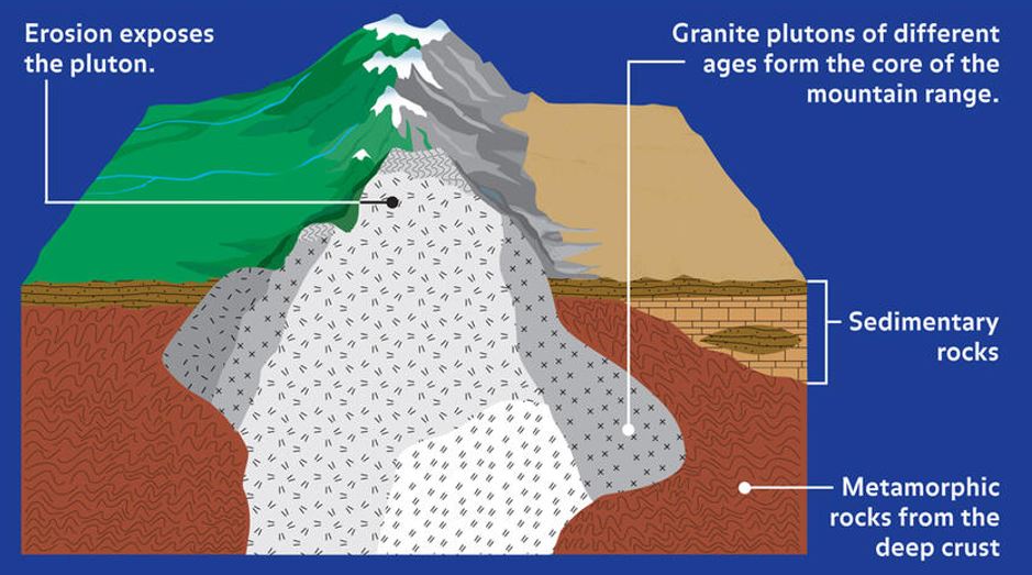
[file plutons.jpg] This diagram shows how plutons are formed as cooled magma bodies
are lifted and then eroded. Credit: American Museum of Natural History
We sit within the overlap zone, where the younger volcanoes, like Baker and Garibaldi erupted up through the older rocks, like plutons and other basement rock. This of course created a whole host of problems, including lava flows which eventually cooled to become basalt as well as ash deposits and lahars (mudflows). You can see evidence of these events in several locations within an hour and a half drive of here.
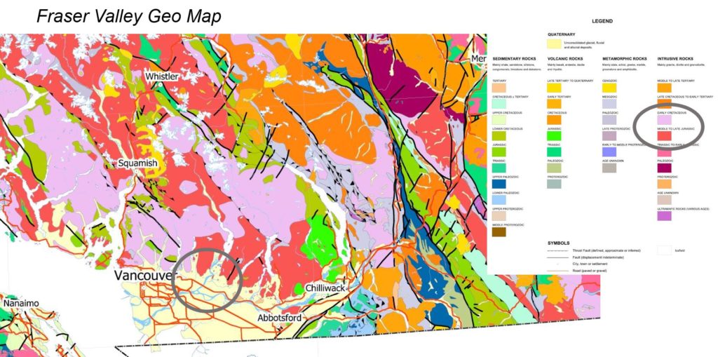
[file geomap.jpg] This image shows the complex geology underlying the South Coast of
BC. The circled area includes Minnekhada in deep pink which indicates Granites of mid
to late Jurassic age. Credit: Geological Survey of Canada
And just to make this whole story a bit more fun. What if I told you that the granites of the CPC did not form here but potentially over a thousand kilometers to the southwest? Wait, what!! Indeed, much of BC is made up of land masses that migrated here from other parts of the world and have been accreted over time. We are a very diverse place in more ways than one!
So now we now the recent story, the much older story and some stuff in between, but how did it all work together the create the landscapes of Minnekhada? I’ll do my best to tackle that next time in part four.
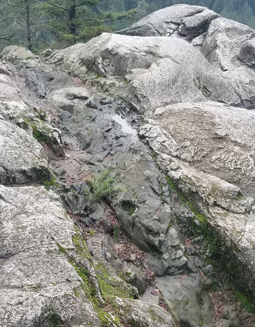
[file: highknoll.jpg] This granitic rock at the top of the High Knoll appears to have been intruded by a different rock type. Credit Steve Smith